

New overall concept for tourism, local recreation and nature conservation
The Marienschlucht is the most famous gorge on Lake Constance. It leads to one of the few natural stretches of shoreline on the lake. In February 2026, it was reopened after being closed for 11 years.
Now you can explore the gorge safely, reaching the shores of Lake Constance via footbridges and paths with breathtaking views along the way: glacial rock formations of the Bodanrück, steep banks oft he lake, which in some places drop vertically almost over 200 metres, the gorge, carved over 100 metres deep into the rocks and only a metre wide in places, and rare animal and plant species, some of which are threatened with extinction, such as the peregrine falcon (Falco peregrinus) and the common raven (Corvus corax), which have their breeding grounds in the impressive ‘Mondfelsen‘, meaning moon rock.
On the rocky ledges from which water flows, one finds unique forms of vegetation, such as mosses that, together with the calcium carbonate in the flowing water, form travertine. Another example worth mentioning here is the water hyssop (Eupatorium cannabinum) and the rare butterfly, the Spanish flag (Euplagia quadripunctaria), which relies on this plant as its sole food source.
The Marienschlucht is located in southern Germany on Lake Constance. The gorge and numerous paths were closed following a fatal accident in 2015. A landslide had claimed one life.
The aim of the planning
Due to the dangerous geological circumstances, the municipalities of Bodman-Ludwigshafen, Allensbach and Constance commissioned the development of a comprehensive plan for the safe reopening of this section. This plan was designed to take into account the interests of tourism, local recreation and nature conservation in equal measure.
365° freiraum + umwelt, in collaboration with Dr. Spang (Geology and Rock Engineering), developed a plan and reopened the beautiful steep-bank landscape in a safe and environmentally sound manner.
As early as 2021, a section of the path along the lakeshore was reopened to walkers. Hazardous areas on the rocks and fallen trees were cleared, and parts of the path were re-routed and restored using simple methods after a long closure.
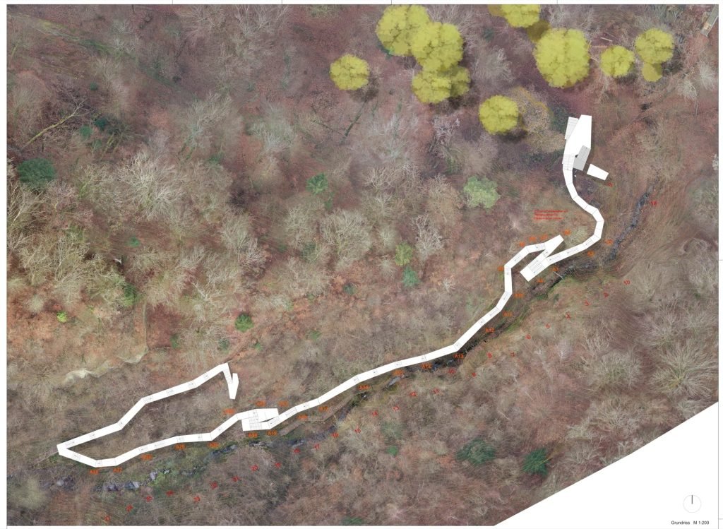
The final section to be opened was a panoramic footbridge through the gorge. 365° freiraum + umwelt identified a safe route based on photogrammetric surveys of the gorge and had it verified through simulations by Dr Spang’s office. The architectural firm Hirthe and the engineering firm Relling, in collaboration with 365° freiraum + umwelt, gave the footbridge its current form. To ensure visitor safety, the path had to be relocated away from the bottom of the gorge and now runs at a height of at least 10 metres, 2 metres away from the slope. This distance enables the footbridge to withstand minor landslides and rockfalls. Due to the permanently damp conditions in the gorge, it was constructed as a galvanised steel structure held in place by compression and tension anchors. This also meant that rockfall nets on the slope could be dispensed with, as these would have severely impaired the sensitive, exceptional vegetation. The new footbridge offers spectacular views.
Visitor management plan
Our initial feasibility study in 2021 had already highlighted potential conflicts regarding species conservation due to the challenging nature of construction work in the gorge. During the implementation phase, the impact of construction activities was minimised by observing quiet periods during the peregrine falcon’s breeding season and by cordoning off critical areas along the access routes. The use of a cable crane system reduced the need for helicopter flights to a minimum. Eroded, essential access routes along the riverbank were secured using Krainer walls, a bioengineering construction method. This was coordinated by the ecological construction supervision team, which scrutinised and optimised every step of the construction process as early as the planning phase.
When the path through the gorge was opened, other paths were abandoned and made inaccessible in order to concentrate people in the area of the gorge, whilst creating quieter zones elsewhere.
The lakeside path to Bodman has also been reopened. It runs directly beneath the 40-metre-high Moon Rock. There is a risk of rockfall, landslides and falling trees here too. Rockfall nets were avoided here, too. A monitoring scheme devised by Dr Spang’s office now ensures that hazardous situations are identified early, involving annual assessments, clearance work, ground sensors on the steep slope and crack monitors on the rock face. In critical weather conditions, gates are closed by a trail warden and hikers are diverted.
The visitor numbers from the first few days clearly show just how keen the public was to rediscover this landscape.
www.365grad.com; www.hirte.com; www.hirte-architekten.de; www.dr-spang.de
https://www.google.com/maps/place/Marienschlucht/@47.765169,9.0920985,17z/data=!3m1!4b1!4m6!3m5!1s0x479a6743a67a9989:0x1c5c0a0f39c8ae85!8m2!3d47.7651654!4d9.0946734!16s%2Fg%2F120s1l25?entry=ttu&g_ep=EgoyMDI2MDQyNi4wIKXMDSoASAFQAw%3D%3D